


Hermann Ward No. 1, Gasconade County, Missouri
About
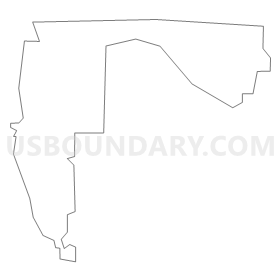
Outline
Summary
| Unique Area Identifier | 607840 |
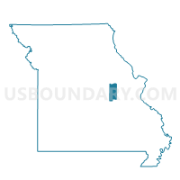
| Name | Hermann Ward No. 1 |
| County | Gasconade County |
| State | Missouri |
| Area (square miles) | 1.71 |
| Land Area (square miles) | 1.42 |
| Water Area (square miles) | 0.28 |
| % of Land Area | 83.41 |
| % of Water Area | 16.59 |
| Latitude of the Internal Point | 38.69941900 |
| Longtitude of the Internal Point | -91.43214460 |
Maps


Graphs
Select a template below for downloading or customizing gragh for Hermann Ward No. 1, Gasconade County, Missouri


Neighbors
Neighoring Voting District (by Name) Neighboring Voting District on the Map
- Gore - Case Voting District, Warren County, MO
- Hermann Ward No. 2, Gasconade County, MO
- Little Berger Voting District, Gasconade County, MO
- Rhineland/McKittrick Voting District, Montgomery County, MO
Top 10 Neighboring County Subdivision (by Population) Neighboring County Subdivision on the Map
- Roark township, Gasconade County, MO (3,774)
- Loutre township, Montgomery County, MO (1,397)
- Bridgeport township, Warren County, MO (743)
Top 10 Neighboring Place (by Population) Neighboring Place on the Map
Top 10 Neighboring Unified School District (by Population) Neighboring Unified School District on the Map
Top 10 Neighboring State Legislative District Lower Chamber (by Population) Neighboring State Legislative District Lower Chamber on the Map
Top 10 Neighboring State Legislative District Upper Chamber (by Population) Neighboring State Legislative District Upper Chamber on the Map
Top 10 Neighboring 111th Congressional District (by Population) Neighboring 111th Congressional District on the Map
Top 10 Neighboring Census Tract (by Population) Neighboring Census Tract on the Map
- Census Tract 8202.02, Warren County, MO (7,508)
- Census Tract 9703, Montgomery County, MO (3,268)
- Census Tract 9601, Gasconade County, MO (2,715)
- Census Tract 9602, Gasconade County, MO (1,926)